Lower Grand Watershed Interactive Tool (WIT) - Lower Grand River 319 Project
Lower Grand River 319 Project
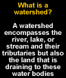
Nonpoint Source Pollutants
Water Science Education
Interactive Mapping
Storm Water Management
Low Impact Development
Government Resources
History of the Watershed
Create a Watershed Management Plan
FYI on Local Water Issues
Rain Gardens
LGRW Implementation Project
Connecting water with life: swimming, drinking, fishing, and enjoying all the waters of our Grand River Watershed.
The Lower Grand River Watershed Project resulted in a nonpoint source watershed management plan for the approximately 3,020 square miles of the Lower Grand River Watershed (LGRW). This was made possible as a result of a 319 Nonpoint Source Watershed Planning Grant. A nonpoint source plan can improve water quality, and the quality of life in human communities. The draft version of the 2010 LGRW Management Plan is now available for review.
The LGRW has many small rivers and streams that have been studied, and some already have their own nonpoint source plans. The idea behind creating a plan for the large basin of the LGRW was to focus human, financial, and technical resources across political boundaries and sub-watershed boundaries. The project included numerous communities, agencies, and institutions. The LGRW boundary falls over ten counties and over 120 sub-watersheds. Many communities gave either time or financial support to this project. Click here to see what communities and agencies were involved in the project.
A portion of the project dealt with two pilot project areas in the LGRW. The LGRW is very large and to gain an understanding of what is happening in the watershed, two smaller subwatersheds were studied. The LGRW was divided into two major land uses, rural and urban. It was decided by project members that one pilot project would be focused on rural watershed issues, Sand Creek Watershed, and that the other would be focused on urban watershed issues, Buck Creek Watershed.
As a result of these pilot projects, two nonpoint source management plans were developed and can now be used as examples for other subwatersheds in the LGRW to make management plans:
Click here for a copy of the Sand Creek Management Plan
Click here for a copy of the Buck Creek Management Plan
Contact:
Grand Valley Metro Council
678 Front St. NW, Ste. 200 Grand Rapids, MI 49503 (616) 776-3876
[email protected]