Current Research
Water scarcity in the Serbian Danube
Climate change is driving water scarcity in the Danube River Basin. As growing season precipitation decreases and becomes more unpredictable, farmers have difficult decisions to make. They can invest in irrigation to sustain yields or transition to less water-intensive crops. Water exploitation will exacerbate scarcity, and could result in a race to the bottom for irrigation access. In Serbia, this process plays out across 630,000 farms that employ 21% of the working population. Meanwhile, thirty years removed from the breakup of Yugoslavia, Serbia is negotiating accession into the European Union (EU). Their integration into the EU single market is increasing agricultural exports and altering domestic agricultural policy. The interactions of market integration, climate change, and increasing water scarcity are uncertain, but they are drivers of agricultural land use change in the region, and understanding the feedback between them is critical.
This NASA-funded research (2022-2024) is quantifying how climate, water scarcity, and changing markets drive farmer decision-making and resulting land use change. We are mapping thirty years of agricultural land use change using Landsat and Sentinel-2 satellites. These maps will be linked to a hydrological model of the Danube River Basin, coupled with conditional crop choice and irrigation adoption socioeconomic models to identify the drivers of agricultural land use change and water scarcity in Serbia. Project co-PIs are Matthew Gammans (MSU) and Tao Liu (MTU), and collaborators Nishan Bhattarai (USDA-ARS) and Oskar Marko (BioSense Institute).
Learn more about this project and the NASA Land-Cover and Land-Use Change (LCLUC) Program.
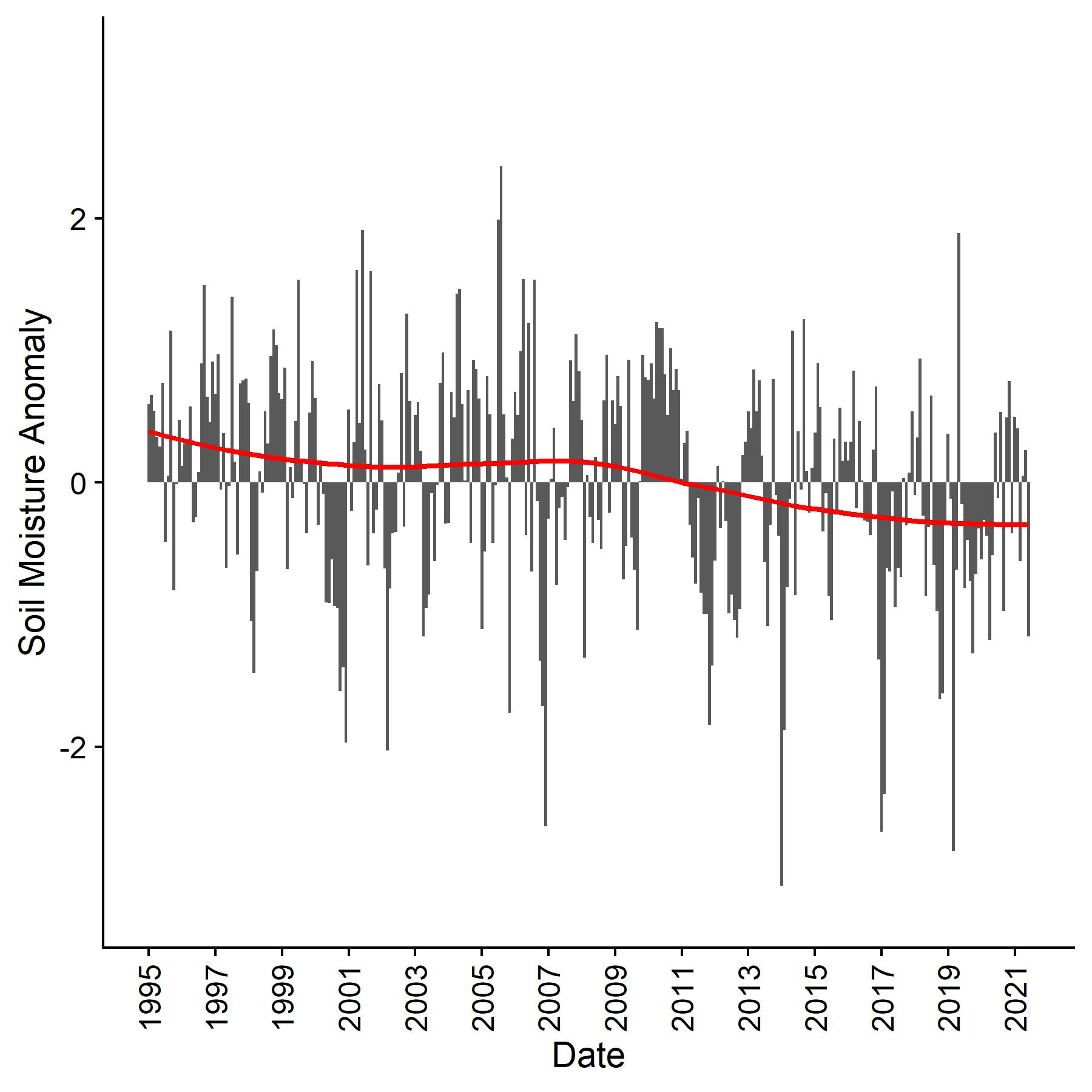
Soil moisture anomaly (SMA) in Serbia’s Vojvodina province. Negative SMA values indicate drier than normal conditions. The SMA demonstrates a drying trend (red line; seasonal Mann-Kendall τ = -0.17, p<0.01). Data source: European Drought Observatory.
Mapping wetlands in time and space with remote sensing
Mapping inundation dynamics
Wetlands provide several key ecosystem services, but over forty percent of Michigan’s original wetlands have been lost to anthropogenic use. Michigan’s wetlands have been mapped, but these maps are static in time and omit inundation dynamics and hydrologic connections within their watersheds. We are using Google Earth Engine and data from the ESA Sentinel-1 synthetic aperture radar (SAR) satellite to map spatiotemporal wetland inundation and connectivity and quantify how anthropogenic development affects inundation and connectivity.
Mapping invasive plants
Michigan's wetlands are under pressure from invasion of non-native vegetation. This project, led by graduate student Jon Walt and funded by the Michigan Space Grant Consortium, is using multispectral (Landsat-8, Sentinel-2) and SAR (Sentinel-1) data in Google Earth Engine to assess current extent of the invasive plants species Phragmites australis and Typha angustifolia and model future habitat suitability given projections of anthropogenic climate change.
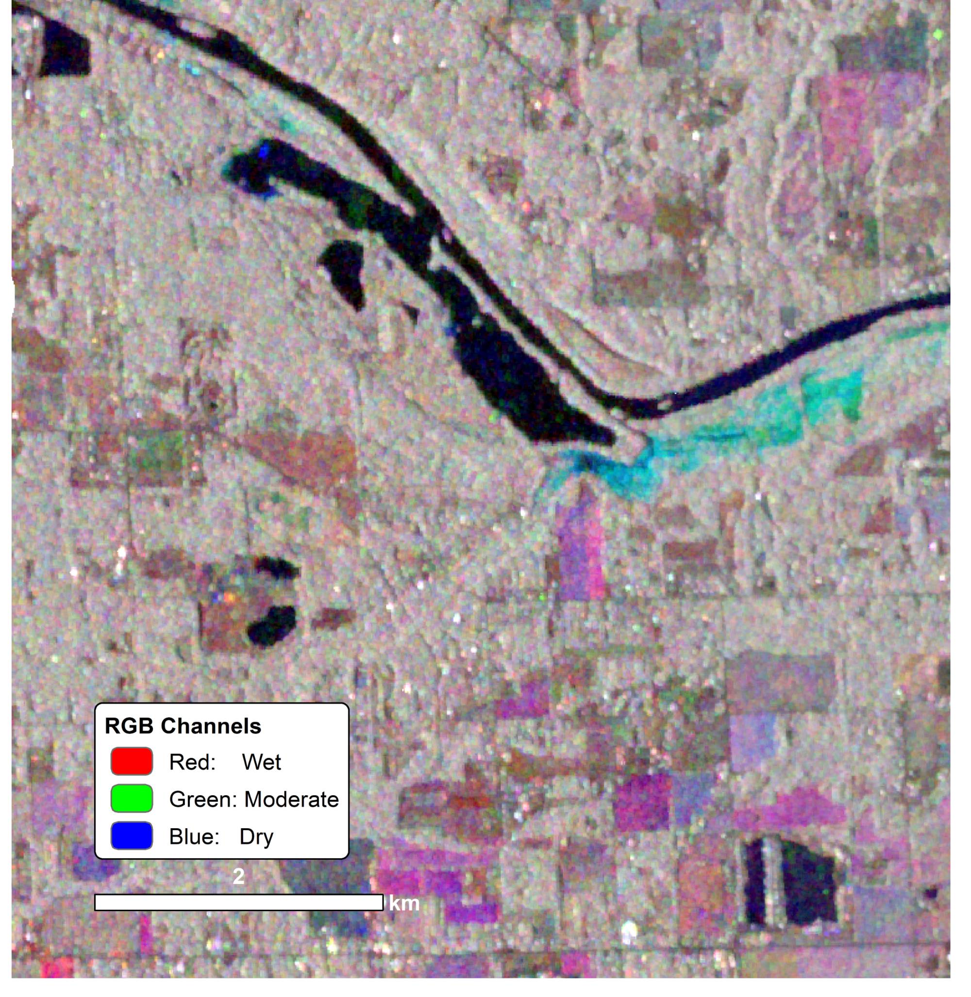
This multi-date, growing season RGB composite of the Grand River near Eastmanville, MI was created using Sentinel-1 images captured in wet, dry, and "normal" conditions. Bright colors show significant changes in scattering mechanisms (e.g. the cyan color shows a wetland that was inundated in the spring and became dry in the summer).