Bear Creek Stewardship Plan - Water Distribution and Use
1. Surface Water
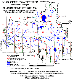
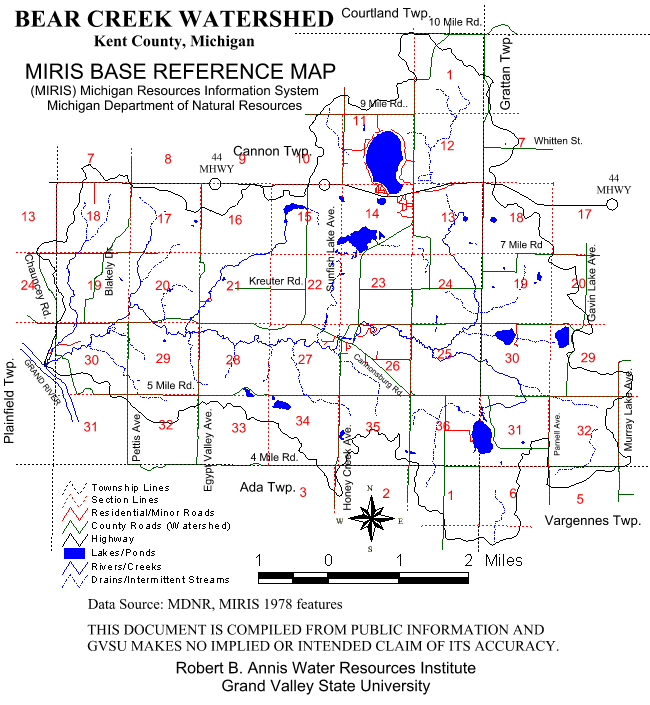
The Bear Creek Watershed is liberally dotted with bodies of water (See Figure 2, p. 9). The most prominent of these is Bear Creek itself which traverses the entire area on its east to west course toward the Grand River. The most prominent named tributaries of Bear Creek are Armstrong, Stout and Waddell Creeks - all three located at or near the western boundary of the watershed and generally flowing in a northeast to southwesterly direction into Bear Creek.
Lakes and ponds of varied sizes are also much in evidence. At least 9 lakes have areas of 5 acres or more. These bodies of water, their locations and areas (in acres) are shown on the chart on page 17.
Figure 5.
Click for larger image
Figure 6.
Click for larger image
Table 1 - Lakes of 5 Acres or More in Bear Creek Watershed
Lake Name
Location (Section #s) C=Cannon/G=Grattan
Area
(Acres)
Bostwick C-11, 14 217 Pickerel C-14 56.9 Ratigan C-36, G-31 56.0 Gavin G-29 approx. 25.0 McCarthy G-30 approx. 20.0 Sunfish C-15 10.6 Hyser C-28, 33 8.5 Little Bostwick C-14 6.8 Austin C-34 5.0
The watershed also has numerous unnamed smaller bodies of water, including farm ponds. Some of these include Pike Pond (adjacent to Bostwick Lake), the Saul Lake Bog, the mill pond remnants at Cannonsburg and Chauncey, and dozens of others.
Nearly 2000 acres or 9% of the watershed are wetlands. These areas include fens, bogs and swamps, with the greatest concentration found in the eastern portion of the area.
The surface waters and lands surrounding them in the Bear Creek Watershed are used generally for recreational, agricultural, and residential purposes. Bear Creek itself is described by MDNR District 9 Fisheries Biologist E.J. Trimberger as "a self-sustaining brook and brown trout stream": however, many longtime residents believe the quantity and size of trout in this waterway have decreased over the past decade. Trimberger himself noted "urban sprawl in the last decade has put considerable pressure on this stream through development in the watershed" (Trimberger, 1990, correspondence).
The main stream channel winds through Townsend Park, the most widely used park in Kent County, but is not used recreationally in this location except as an aesthetic feature because of extensive sedimentation and the fact that it has been placed off limits for total body contact (i.e., swimming) by the Kent County Health Department due to fecal coliform contamination. Several unnamed tributaries of the main stream originate within or traverse the Cannonsburg Game Area, an area of some 600 acres south of Bear Creek in Sections 27 and 28 of Cannon Township owned and managed by the Michigan DNR. Apart from any recreational fishing which takes place in this public wildlife preserve, fishing in the stream and its tributaries is mostly accomplished from privately owned streambanks.
There is little public access to the Bear Creek stream corridor for public fishing, camping, or other outdoor recreational activities, except hunting in the Cannonsburg Game Area. Bear Creek is not now and apparently has never been a navigable stream. Most streambank residents consider that the watercourse, as well as the land surrounding it, is theirs and landowner permission must be secured to access nearly all portions of the stream, either from the banks or from within the stream itself.
Several of the watershed lakes are also "ringed" by private property owners. These include Bostwick Lake, Ratigan Lake, and Sunfish Lake, three of the largest bodies of water. At these lakes, small lots completely encircle the water and individuals own land right up to the water's edge. Use of these lakes is primarily restricted to individuals owning these properties. Uses include fishing, recreational boating and canoeing, and waterskiing. In decades past, the homes around these lakes were second or "summer" homes; however, more recently these residences are occupied year-round by their owners who utilize them as their primary homesites.
Pickerel Lake and the approximately 200 acres surrounding it are currently being developed into a Kent County park facility to be called Pickerel Lake-Fred Meijer Nature Preserve. This preserve will allow public access for fishing and other outdoor recreational activities on the site. Hyser and Austin Lakes are located mostly in the Cannonsburg Game Area and may be fished by the public year-round: Ice fishing is a popular sport on these bodies of water.
Most of the lakes in the watershed and the portions of the surface of Bear Creek and its tributaries freeze in the winter months. Some of the springs feeding the stream system flow only intermittently, in the spring and early summer; however, most are perennial and continue to flow throughout the winter months as well.
2. Groundwater
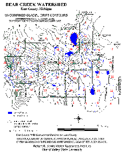
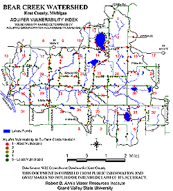
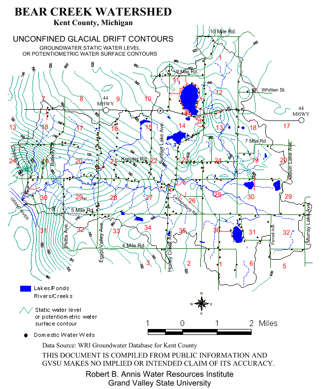
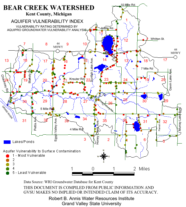
Wells provide all of the water for residential, commercial, and industrial use within the watershed. Most of these wells draw from the confined glacial drift aquifer which is separated from the ground surface by a confining layer of clay or rock. Some wells draw from the unconfined aquifer which is more vulnerable to contamination from the ground surface. Figure 7 identifies water well locations and the static water level of unconfined glacial drift aquifers. Figure 8 identifies the relative risk of groundwater contamination of wells in the area. As is evident, the sites at greatest risk are not concentrated in one location, but are scattered throughout the watershed.
3. Rainfall in the Watershed
The 24-hour rainfall frequencies for the watershed from the Rainfall Frequency Atlas of the United States (1961) are as follows:
Table 2
Time
Rainfall Period
Amount
1 year 24 hour 2.20 inches 2 years 24 hour 2.45 inches 5 years 24 hour 3.15 inches 10 years 24 hour 3.65 inches 25 years 24 hour 4.15 inches 50 years 24 hour 4.55 inches 100 years 24 hour 4.90 inches
Figure 7.
Click for larger image
Figure 8.
Click for larger image