Bear Creek Stewardship Plan - Soils
A modern soil survey was completed for Kent County in 1983 by the USDA Soil Conservation Service. Soils identified in the Bear Creek Watershed were primarily sand, loamy sand, sandy loam and loam with some muck soils in the low lying areas. These soils are formed by glacial deposits acted upon by soil formation processes such as wind, water and the decomposition of organic matter. As a result of the chaotic distribution of parent materials by glacial action, soil types vary substantially from site to site in the watershed. The percentage breakdown of these soils is shown in Table 3 below (Fulcher, 1991, p. 7):
Table 3 - Soil types in the bear creek watershed by group and percentage
Soil group
Soil Type
Percentage
A. Sand, Loamy Sand 43% B. Sandy Loam, Loam 37% C. Silt loam, Sandy Clay Loam 3% D. Clay Loam, Silty Clay Loam, Sandy Clay, Clay 17%
Because of the high percentage of soils from groups A and B (80%) in the watershed, the runoff potential is very low when these soils are left undeveloped. As a result, Bear Creek historically has not been prone to flash flooding during periods of above average rainfall.
Low runoff potential for soils is associated with a high infiltration rate. Infiltration rates for the soils present are noted in the Table on the following page (Fulcher, 1991, p. 6)
Table 4 - Texture Class and Infiltration rates of Bear Creek Watershed Soils
Soil Type
Minimum Infiltration Rate in inches per hour
Sand 8.27 Loamy Sand 2.41 Sandy Loam 1.02 Loam .52 Silt Loam .27 Sandy Clay Loam .17 Clay Loam .09 Silty Clay Loam .06 Sandy Clay .05 Silty Clay .04 Clay .02
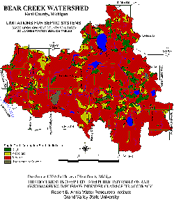
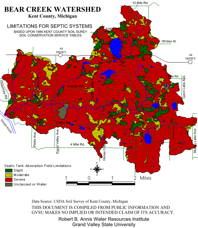
According to the 1983 Soil Survey, substantial parts of the watershed have soils which impose severe limitations on septic tank absorption fields. These soils are generally concentrated in large groups, with some smaller units scattered through the area. Soils with severe limitations for septic tanks comprise about 55% of the total watershed area. Soils with moderate limitations comprise another 34% of the area, while soils with slight limitations cover about 8%. Soils pose limitations for a variety of reasons including their slope, wetness and permeability (Figure 9). Public sewer systems within the watershed are available for developments around Bostwick Lake, Sunfish Lake and the Grattan Township portion of Ratigan Lake. The remainder of residential, commercial and recreational facilities are served by septic systems. There is one septic dumping site located in the watershed where Cannon Township septage is spread after it has been removed from township residents' tanks. Another feature of interest related to soil type and watershed management is Tc or "time of concentration," defined as the time it takes for rainfall to travel from the hydraulically most distant point of a watershed to the outlet of the subbasin. Appendix A shows the Tc (in hours) for the 37 subwatersheds within the Bear Creek Watershed identified by Fulcher in 1991 (p. 15) using 1978 conditions. As is evident, the Tc ranges from 14.78 hours in subwatershed 4 located at the easternmost edge to .27 hours in subwatershed 24 located near Austin and Heyser Lakes adjacent to one of the areas historically considered to be "non-contributory" (Fulcher, 1991, p. 15).
Figure 9.
Click here for larger version
Flow measurements are also available for this watershed. Flow measurements were taken at 10 locations by Fulcher (1991, pp. 18-19). The results are noted in Table 5. In addition, the estimated 5% and 95% monthly exceedance flows were computed. The 95% exceedance flow means that a given volume or more of water would be expected in the stream 95% of the time, when averaged over a long period of time. The same is true for the 50% exceedance flow. Estimated exceedance figures for the watershed are shown below.
Table 5 - Monthly exceedance flows for Bear Creek in cubic feet per second
Month
95% exceedance
50% exceedance
January 16 24 February 18 25 March 22 42 April 25 44 May 18 29 June 15 24 July 11 21 August 11 19 September 12 20 October 13 23 November 16 26 December 20 28
The estimated annual flow durations for Bear Creek at 29.6 square miles in drainage area have been calculated as:
0% 51 cfs
25% 39 cfs 50% 30 cfs 70% 26 cfs 75% 24 cfs 90% 20 cfs 95% 17 cfs
On the basis of these figures, the estimated average annual flow has been calculated at 28 cfs (Fulcher, 1991, p. 18). Again, these flow figures are consistent with Bear Creek's history of being a relatively non-flashy stream when soils, slopes, the streambank, and streambed are in a relatively natural state.