Bear Creek Stewardship Plan - Nonpoint Source Pollution

At least four general categories of nonpoint source (NPS) pollution are found in the watershed. These are agricultural, residential/urban, transportation-related, and, to a lesser extent, stream-based pollution. At the present time, most of the areas of the watershed are not developed for residential or commercial use, but this pattern of land use is changing. With this change, the relative impact of each NPS within the watershed is modified as well. For the present, it is most accurate to characterize concerns as revolving principally around historical practices of agricultural land management and evolving practices of residential/commercial land development. Strategies of dealing with the former are restorative and remedial, while those of dealing with the latter are more preventive and protective.
1. Agricultural NPS Pollution
A significant amount of the NPS pollution in the Bear Creek Watershed is associated with longstanding agricultural practices including the management of crops and livestock, including livestock waste and livestock watering needs. These practices are associated with agricultural holdings large and small, including a number of small acreage "hobby farms" which may have only a few horses or other farm animals.
According to the 1986 USDA Soil Conservation Service Kent County Soil Survey, the character of the topology and texture of surface layer of soils in the watershed can be described as gently rolling to very steep, somewhat excessively drained to well-drained with sandy and loamy soils formed in loamy and sandy deposits. The entire area is generally mapped as representing soils from the Marlette-Chelsea-Boyer association. The SCS uses a classification that divides land into eight land capability classes according to its erosion hazard and other limitations. Class I land has few limitations for crop land while Class IV land has a very severe erosion hazard when used for crops. Class V land has other limitations that preclude cropland use; Class VI land is generally restricted to pasture or forestry uses due to erosion potential and other limitations; and, Class VIII land has limitations that preclude even forest and pasture usage.
Some soils in the watershed are considered prime farmland when they are found under the specified conditions. These include Oswosso-Marlette sandy loams (Map symbol 11B), on 2 to 6 percent slopes; Marlette loam (Map symbol 36B), on 2 to 6 percent slopes; and Marlette loam (Map symbol 83B), moderately wet, on 1 to 5 percent slopes. As noted earlier, the slope of most of the land in the watershed exceeds 5 percent. In fact, much of the area has a slope in excess of 12 percent, rendering these soils much less suitable for farmland uses than they would be on a more level topography.
In general, Marlette-Chelsea-Boyer association soils have mid- to low-capability agricultural ratings and are considered to yield few or no crops per acre, even under high levels of management. In the Boyer association the land capability classes are III, IV, and VII; in the Marlette association the capability classes are III, IV, VI and VII; and in the Chelsea association capability classes are IV, VI and VII.
According to the SCS District Conservationist Steve Utic, approximately 40 percent of the cropland acreage in the watershed is in need of conservation practices to modify loss of soil to wind and water. There are a significant number of acres eroding at a rate which exceeds the productivity level of the land. Much of this eroded soil finds its way into the watercourses of the watershed where it becomes a major contributor to in-stream sedimentation. Some 60% of the agricultural lands in the watershed currently employ conservation tillage practices which reduce erosion hazards significantly.
Other agricultural practices related to water quality issues include crop rotation practices, fertilizer, herbicide and pesticide application methods, and practices related to livestock management. Problematic livestock accessibility to the surface waters of the stream system has been documented throughout the watershed, and there are many feedlots which contribute significant levels of manure as runoff during rain events or periods of snow melt. Not only do these management practices permit the introduction of untreated animal wastes directly into the riparian environment, the livestock also degrade the streambanks and wetlands of their pastures and feedlots by compacting the soils and adding soil materials to the stream. The extent of the impact of the confined animal operations to severe, very severe or extremely severe nonpoint source pollution of the stream system is not currently known.
Problems also exist with the application (or mis-application) of manure to croplands, including overapplication and inappropriate incorporation of the manure into the soil.
A related concern - though not one strictly confined to agricultural land uses - is stream diversion and damming with associated obstructions to the natural patterns of fish migration and water flow. During the field inspection of the watershed, several sites have been located where dams have been built along the main channel or tributaries or where the stream has been diverted. Some of these structures and diversions are very recent, others were completed 30 or more years ago.
At least one of these sites poses an imminent danger to areas of the streambank and water channel downstream because the dam is old, spongy, and unstable. The dam at this particular site is one of the older structures and its placement in the stream has created a "hanging pond" of considerable volume at a HEIGHT some 100 to 150 feet above the natural stream bed.
At two other sites on the stream, remnants of old mill ponds exist. These continue to influence water flow and determining the original or "natural" route of water is difficult, as is conceptualizing ways to restore the sites without creating greater disturbances than already exist.
At still another site, a tributary of Bear Creek was dammed to form a wildlife habitat on private property. The landowner currently appears to be continuing with unknown plans for site development which includes the pond created by stream damming.
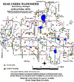
Agricultural NPS pollution sites in the watershed are noted in Figure 13.
Figure 13.
Click here for larger version
2. Residential/Suburban NPS Pollution
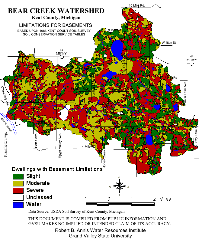
As the watershed has evolved from an area once characterized as rural to an area now more accurately characterized as suburban, the suitability of its land and water resources for sustaining residential and commercial uses has required close evaluation. Most of the soils in the watershed have moderate to severe limitations for septic systems and basements (See Figures 9 and 14). The SCS notes that the limitations on Marlette-Chelsea-Boyer association soils for building site development as "severe" for shallow excavations and "slight" to "severe" for dwellings with or without basements, small commercial buildings, and local roads and streets. Limitations on these soils for lawns and landscaping is considered to be "moderate" to "severe" due to small stones and slope.
It is interesting to note that the lands with the most severe limitations have generally been the lands which have recently undergone the most residential development. These include watershed parcels with extremely steep slopes, as well as areas around lakes and near the stream corridor where septic or basement limitations are particularly severe due to soil permeability, slope, or aquifer proximity.
The potential for septic system malfunction is high under the soil and slope conditions within much of the watershed, particularly if septic system owners do not maintain these systems appropriately with regular pumping. Since bacterial contamination of the ground and surface water is a major concern, significant attention has been directed toward determining the role septic systems have in this contamination. At the present time, information is not available upon which to base firm conclusions, however, it is obvious that, at the least, all present and future watershed residents - along with residential and commercial developers - must be educated about the appropriate installation and maintenance of septic systems. Furthermore, at some point, residents and elected officials of the communities comprising the watershed must determine whether alternative methods of human waste disposal pose fewer health and environmental hazards than the septic systems now in use.
Figure 14.
Click here for larger version
The residential and small business focused commercial development which has occurred in the watershed has been accompanied by an escalation of others threats to water quality. These include increases in the amounts of paved, impervious surfaces and associated increases in the amount and velocity of stormwater runoff from roadways, rooftops, driveways and parking lots; decreases in the amount of natural vegetative cover, including trees, native grasses, and shrubs; increases in the amounts and types of fertilizers, herbicides, pesticides, and other chemicals used on yards and lawns (some of them adjacent to the stream system); and increases in the presence of other NPS pollutants such as gasoline, fluorocarbons, anti-freeze, oil, and household chemicals which may find their way into ground and surface waters. Furthermore and not surprisingly, as residential development increases, the demand for golf courses also increases, and golf course management typically involves the application of a wide range of chemicals to maintain fairways, greens, trees, and insect populations.
Residential and commercial development also brings more and more humans into the watershed on a regular basis and they are naturally drawn to the water resources. Problems of increased amounts and types of litter and trash in the stream and along its banks is one unfortunate and unsightly consequence. Adopt-a-Stream teams regularly schedule "stream cleanups" to remove debris which has been thoughtlessly left by humans using the stream for recreational purposes or as a convenient "dump" for unwanted items. Paper, styrofoam, aluminum, glass, rubber, cloth and other manufactured materials and items large and small are regularly removed as part of these efforts designed to preserve the many aesthetic features of this unique stream system.
3. Transportation Related NPS Pollution
As the Bear Creek Watershed has moved from low density agricultural land use to higher density residential and commercial land use, certain transportation concerns with an impact on water quality have become evident. Among these are gravel roadways whose stormwater runoff contributes to stream system sedimentation; concern with the appropriate design, installation and maintenance of ditches, culverts, and drains which move water from roadways to the watercourses; concern with the maintenance of stream-road crossings, and concern with the contribution of gasoline, oil, anti-freeze and other transportation-related road surface contaminants to the stream system via stormwater runoff.
In the winter, an additional concern is added with respect to the sodium chloride (salt) used to de-ice roads and bridges. In particular, attention is directed toward the influx of chloride into the stream system during the first flush of spring rains. Previous studies have suggested that the presence of high levels of chloride during a period of the year when biological activity is high (such as the early spring) can be particularly damaging to aquatic life (Smith Drain Pilot Watershed Plan, 1990).
At the present time, approximately 80% of the roads in the watershed are paved. These are maintained by the Kent County Road and Parks Commission. Many of the unpaved roads of the area are located in the Cannonsburg Game Area. These roads are particularly vulnerable and are not intended to accommodate levels of traffic beyond the lowest service levels. Cannon Township has been paving, on average, approximately one mile of gravel roadway in its township boundaries each year. While the paving reduces erosion-related water quality problems, these paved surfaces add to runoff problems associated with water velocity and the roadway pollutants already discussed. Furthermore, as the Cannon Township Comprehensive Plan notes, improved roadway networks can attract new or expanded intensive land uses - and these can place increasing demands on water resources as well as require further improvements in the transportation infrastructure (Cannon Township Comprehensive Plan, 1993, C-5).
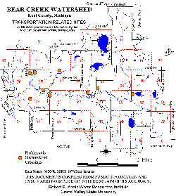
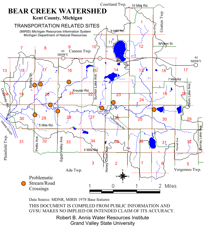
As a result of the field assessment of the stream system, several sites of NPS pollution related to transportation structures (roads, bridges, ditches, culverts, etc.) have been identified. These are shown in Figure 15.
4. In-Stream/Lakefront Related NPS Pollution
The most significant in-stream/lakefront source of NPS pollution is bank erosion which creates additional sediment. Bank erosion is promoted by high water velocity, human and animal foot traffic along banks and within the stream/lake system itself, and road and stream crossings lacking appropriate BMPs for erosion control.
An estimated 10 percent of the entire stream system's bank area was considered to need stabilization to reduce NPS pollution.
Figure 15.
Click here for larger version