Bear Creek Stewardship Plan - Overview of Geophysical Features
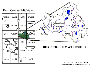
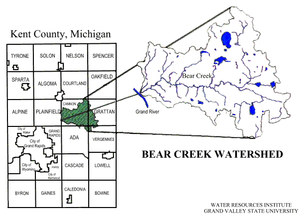
The Bear Creek Watershed drains 20,096 acres of rolling hills and steep slopes in northeastern Kent County, Michigan. Although the watershed is located primarily within Cannon Township, approximately 15% of its total area lies within Grattan Township, and significantly smaller amounts are within Ada, Vergennes and Plainfield Townships as well (See Figure 1). Slightly more than half of Cannon Township (55%) is encompassed by this watershed.
The surface features of the watershed resulted from periods of glaciation some twelve to twenty thousand years ago. Landforms created by glacial action include terminal moraines which make up the steepest hills in the watershed; the gently rolling "swell and swale" topography associated with the agricultural lands in the eastern part of the watershed; Bear Creek and the surrounding valley along Cannonsburg Road which began as an outwash channel for glacial meltwater; and kettle lakes formed in the depressions where huge blocks of ice melted in situ.
Along with most of Kent County, the watershed is located on the boundaries of two of Michigan's principal bedrock formations: the Marshall and Michigan formations. These are the first to be encountered beneath the area's glacial deposits. The Michigan formation underlies about half of the watershed, primarily to the northeast. The Saginaw formation underlies most of the remainder. Thickness of glacial deposits overlaying sandstone and shale bedrock ranges from approximately 50 to more than 300 feet in the area, increasing generally from southwest to northeast, with no known outcropping of bedrock in the watershed itself (Cannon Township Comprehensive Plan, 1992, p. C-1).
The geomorphology of the area has been strongly influenced by the confluence of the Michigan and Saginaw glacial lobes, resulting in a rather chaotic and visually interesting topography. The glacial till and outwash plains that dominate the surface were deposited during the Wisconsin stage of the Pleistocene period. Drift deposits vary considerably, depending of their mode of deposition, and consist mainly of unconsolidated sand, gravel and clay. These are hydrogeologically important constituents of glacial drift aquifers (Lacey, 1991, p. 5).
Figure 1.
Bear Creek is the major watercourse in Cannon Township. As it runs east to west for some 17 miles, the creek and its tributaries are surrounded by wooded upland areas which slope abruptly downward toward the narrow floodplain of the creek's main channel. The result is a long and picturesque valley which is most evident when traveling along Cannonsburg Road, a major thoroughfare of the area (Cannon Township Comprehensive Plan, 1993, 2-3).
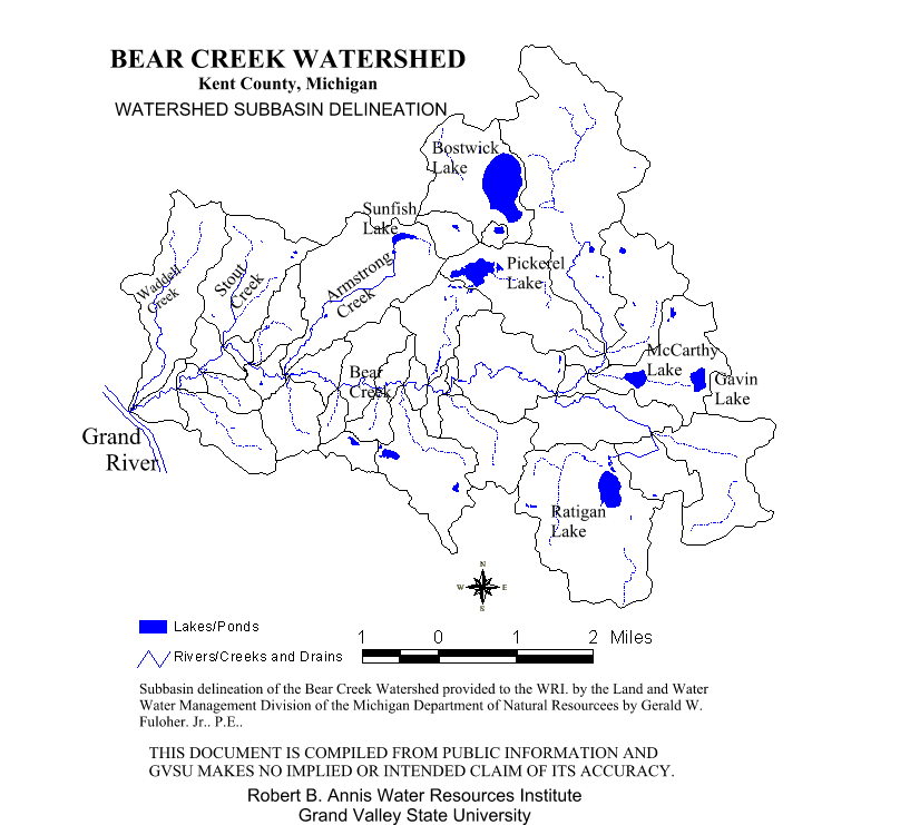
The watershed includes many tributaries, lakes and wetlands. Stout and Armstrong Creeks are two of the largest tributaries which flow into Bear Creek from the north, while many smaller perennial and intermittent streams contribute along its entire length. Lakes range in size from 1 acre to slightly more than 200 acres and include Sunfish, Ratigan, Bostwick, Little Bostwick, Hyser, Austin, McCarthy, Gavin and Pickerel Lakes as well as a number of smaller (often unnamed) lakes and ponds, some of them private.
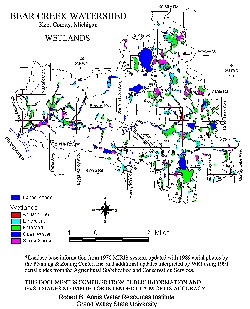
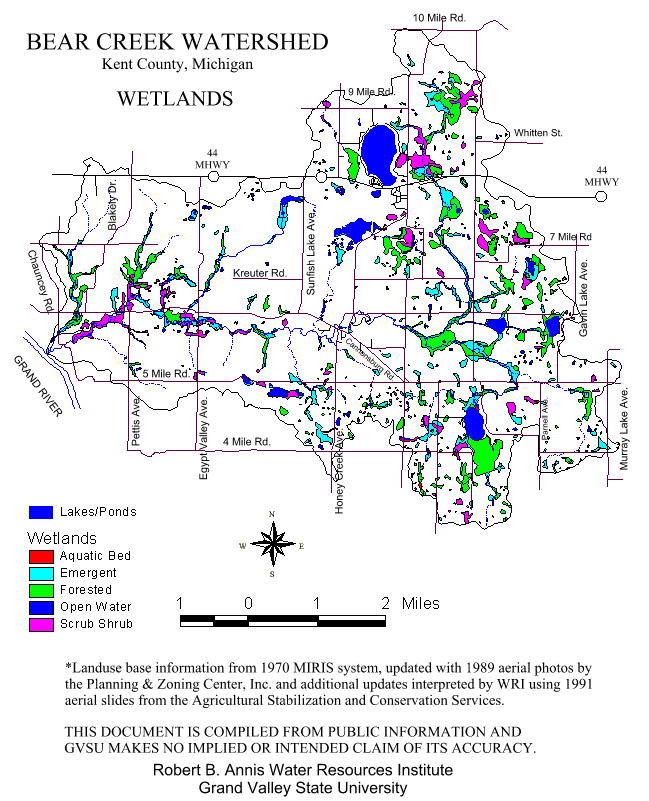
There are an estimated 2000 acres of wetlands in the watershed. These are primarily located adjacent to Bear Creek and its tributaries (See Figure 2), in the eastern portion of the watershed. For the most part, these wetlands are lowland forests and shrub swamps and include the Saul Lake Bog. Many of the larger wetlands are contiguous; however, there exist literally hundreds of isolated wetland areas throughout the watershed.
The average slope of Bear Creek is .35% (18.6 ft/mile). The tributaries in the eastern portion are generally no steeper than this, in fact, some are flatter. On the other hand, the tributaries in the western portion are much steeper, with slopes to 2.8% (150 ft/mile) (Fulcher, 1991, WIDTH of the stream ranges widely, from approximately 18 inches along some branches to more than 30 feet in the main channel near the Grand River. The depth ranges significantly as well, from long stretches just a few inches deep to pools several feet in depth.
The slopes of the landforms adjacent to Bear Creek are significantly steeper. Substantial areas of Cannon Township, for example, have slopes of 12% or greater. The absolute topographic relief in Cannon varies from a maximum elevation of 1,000 feet in Section 1 to a minimum of 605 feet in sections 30 and 31, at the Grand River (Cannon Township Comprehensive Plan, 1993, C-2).
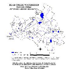
Watersheds adjacent to Bear Creek include Rum Creek and Seely Creek to the north, Barkley Creek to the northwest and Egypt Creek to the south. All of these, including Bear Creek, are sub-watersheds of the Grand River (See Figure 3). Bear Creek enters the Grand River approximately 45 miles upstream from Lake Michigan.
Figure 2.
The northernmost headwaters of Bear Creek originate in springs near Bostwick Lake, the largest lake in the watershed with a surface area of about 210 acres. From this point of origin, the creek flows south some 2 miles, then turns west, through the village of Cannonsburg and toward the Grand River. Several dozen feet before Bear Creek empties into the Grand River, Waddell Creek enters Bear Creek (See Figure 4). Waddell Creek is considered one of the many subwatersheds of the Bear Creek Watershed.
Another origin for Bear Creek is located in Section 7 of Vergennes Township, in an area comprised both of springs and wetlands. Springs are prominent throughout the watershed, the large majority of them perennial or flowing year-round. In some locations, five or more springs can be found contributing water to the flow of Bear Creek in each half mile section. In other locations, dozens of springs are found within visual distance of one another along the main stream corridor.
There are two areas within the boundaries of the watershed which historically have been considered as "non- contributing" (i.e., as retaining all of their rainfall except during periods of very heavy rain). One of these areas drains into Bostwick, Little Bostwick and Pickerel Lakes; the other, into Hyser and Austin Lakes. In the course of evaluating the watershed, it has been determined that as the levels of these lakes have increased some contribution to the watershed has begun to occur regularly, particularly from the area around Bostwick Lake, an area which has experienced significant residential development.
Figure 4.
Click here for larger image
In late-1991, approximately 28% of the watershed area was shrub/scrub/swamp and recreational land; 28% was agricultural (with some two-thirds of this devoted to row crops, nearly a third to livestock farming, and less than one-tenth to orchard crops); 26% was forested; 10% was urban; and nearly 8% was wetlands. One trend between 1991 and 1993 was toward the conversion of agricultural land to residential development, with several new housing subdivisions underway. Another was toward the donation of private lands for conservation or natural resource preservation purposes. Recreational land within the watershed includes both private and public land -- including the privately owned Cannonsburg and Pando Ski Lodges, Kent County's Townsend and Pickerel Lake Parks, Kent County's Harry and Josephine Luton nature conservancy, Natural Areas Conservancy of Western Michigan's Saul Lake Bog, Christian Youth Camp Association's Camp Roger, Isaac Walton League's Dwight Lydell Chapter Preserve, and the Michigan DNR's Cannonsburg State Game Area.