Project Detail
Project Goal
Identify and provide preliminary monetary economic values for green infrastructure and its associated ecosystem services in seven (7) counties in West Michigan.
Determining Ecosystem Services Values for West Michigan
- The methodology utilized for this project was adapted from (Troy and Wilson 2006).
- The total estimated value of ecosystem services in West Michigan includes the estimated values for all of the selected ecosystem services associated with the selected land uses in the seven-county project region (2,825,809.05 acres + 123.16 miles of rails-to-trails) per year. No ecosystem services were associated or valued for urban or developed lands. All values have been adjusted to 2006 dollars (Bureau of Labor Statistics 2007).
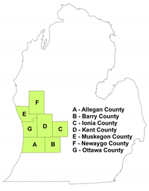
- The project area includes the Allegan, Barry, Ionia, Kent, Muskegon, Newaygo, and Ottawa counties. This seven-county region, located in Michigan's lower peninsula, make up the West Michigan Strategic Alliance policy region. The total estimated value of ecosystem services for each county includes the estimated values for all of the selected ecosystem services associated with the selected land uses in that county (number of acres + number of miles of rails-to-trails) per year.
- This seven-county region encompasses 4,729 square miles, three metropolitan centers, and is home to over 1.2 million people. Kent and Ottawa counties have the highest population densities (671.0 and 421.0 per square mile, respectively) and Newaygo and Barry counties have the lowest population densities (56.9 and 102.1 per square mile) (U.S. Census Bureau 2000). The region-wide annual median household income (2004) is $46,149, which ranges from $38,626 in Muskegon County to $55,011 in Ottawa County (U.S. Census Bureau 2007).
- The policy region also has unique and abundant natural features and resources: 75.6 miles of Lake Michigan shoreline and 6,881.5 miles of flowing rivers and streams, including sections of five of Michigan's 16 designated Natural Rivers (West Michigan Strategic Alliance 2007; Michigan Department of Natural Resources 2007).
- The project team identified key ecosystem services based on their regional significance, and associated them with West Michigan land uses.
- The land use data utilized for this project were adapted from the 1999-2001 Integrated Forest Management Assessment and Prescription project (IFMAP) for West Michigan (Michigan Department of Natural Resources and U.S. Forest Service 1999-2001). The 30 IFMAP land use categories were combined into nine broad project land use categories to simplify the discussion of valuing ecosystem services within the region.
|
Project Area Land Use Categories |
IFMAP Land Use Categories |
|---|---|
|
Cropland |
Row Crops, Non-Vegetated Farmland |
|
Orchards and Specialty Crops |
Orchards / Vineyards / Nursery |
|
Forest Land |
Northern Hardwood Association, Oak Association, Aspen Association, Other Upland Deciduous, Mixed Upland Deciduous, Pines, Other Upland Conifers, Mixed Upland Conifers, Upland Mixed Forest, Lowland Deciduous Forest, Lowland Coniferous Forest, Lowland Mixed Forest |
|
Grass, Shrub and Prairie Land |
Row Crops, Non-Vegetated Farmland |
|
Water |
Water, Floating Aquatic |
|
Wetlands |
Emergent Wetlands, Mixed Non-Forest Wetlands |
|
Sand Dune/Beach |
Great Lakes Dune and Beach Complex |
|
Other Bare Land |
Great Lakes Dune and Beach Complex |
|
Developed Area |
Low Intensity Urban, High Intensity Urban, Parks/Golf Courses, Airports, Roads/Paved |
- Benefit transfer is the economic valuation methodology used to assign economic values to ecosystem services. Benefit transfer is the use of existing valuation information for one good or service from a study area to estimate the value of a similar good or service in a targeted policy area. It is widely used and relatively inexpensive, and benefit transfer generates important information that is useful to decision-makers.
- However, the use of benefit transfer provides only an estimated value of the good or service in the targeted policy area. The study area from which the value of a good or service is being transferred must be similar to the targeted policy area. The more differences between the two areas, the greater the error in the transferred value.
- Team members reviewed studies from various economic and valuation databases and compiled bibliographies: EcoValue Project (Wilson et al. 2004), EconLit, Bibliography of Economic Valuation Literatures (Defenders of Wildlife 2006), National Ocean Economics Programs Non-Market Values Portal (https://www.oceaneconomics.org/nonmarket/), an annotated review of wetlands and economics literature (Bardecki 1998), and individual bibliographies from many of the papers found. We accepted papers from academically peer reviewed journals, government reports, and dissertations. This resulted in more than 327 papers on the ecosystem services and land uses that are the focus of this study. All papers were screened for their applicability to the West Michigan policy region, as well as the transferability of the data to an annual per acre figure.
- Team members also had to supplement this literature search with West Michigan regional data. These included demographic, farmland food production, and sand and gravel mining data from the U.S. Census; Michigan GIS hydrology data; farmland leasing rates from Michigan State University Extension; trust land property from the Land Conservancy of West Michigan; hunting and fishing data from the Michigan Department of Natural Resources; boater registration data from the Michigan Secretary of State; and beach, park and trail usage data from federal, state and local parks within the seven-county project region.